561.536.3650

INFRASTRUCTURE AERIAL SERVICES
RELIABLE PRECISE VISUAL
High-Accuracy, High-Efficiency Aerial Imaging for Critical Infrastructure Projects
At 561AERIALS, we provide specialized aerial photography and videography solutions to support infrastructure development, inspection, and long-term asset monitoring. Our drone-based imaging gives engineering teams, contractors, utilities, and municipalities the clarity they need to make informed, data-driven decisions without disrupting active worksites.
What We Cover
We support a wide range of infrastructure projects, including:
-
Roads, Highways & Interchanges
Progress tracking, traffic-flow overview, and pre-/post-construction documentation. -
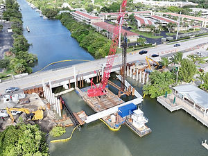
Bridges & Overpasses
Structural visualization, elevation perspectives, and condition reporting. -
Utility & Energy Infrastructure
Water treatment facilities, power distribution sites, solar fields, substations, pipelines, and more. -
Public Works & Municipal Projects
Parks, drainage improvements, stormwater systems, public buildings, and community development projects. -
Industrial & Transportation Facilities
Ports, rail corridors, logistics centers, and heavy-equipment construction zones.
Why Use Aerial Imaging for Infrastructure
Infrastructure projects are complex, long-term, and require consistent oversight. Our aerial services deliver:
✔ Comprehensive Progress Visibility
Track every phase from groundbreaking to completion with consistent, same-angle updates.
✔ Engineering-Grade Accuracy
High-resolution imagery, precise geolocation, and detailed top-down mapping.
✔ Improved Coordination
Share visuals instantly with contractors, stakeholders, inspectors, and municipal partners.
✔ Safety-Focused Data Collection
Capture areas that are difficult, hazardous, or impossible to inspect from the ground.
✔ Regulatory & Documentation Support
Ideal for planning reviews, compliance reporting, permitting, and public presentations.
Our Infrastructure Deliverables
561AERIALS provides a complete suite of deliverables tailored for infrastructure and civil engineering teams:
-
High-resolution aerial photos
-
Construction progress videos
-
Orthomosaic mapping
-
4K cinematic project flyovers
-
Pre-construction & as-built documentation
-
Site overview comparison reports
-
Visual data packages for stakeholder meetings
-
Long-term project archives for future reference
Built for Long-Term, Multi-Year Projects
We work seamlessly with contractors, engineering firms, and government agencies to establish structured imaging schedules—monthly, biweekly, or custom-timed capture plans—ensuring consistent, standardized documentation throughout the entire lifecycle of a project.
Why Choose 561AERIALS
-
Specialized in construction & infrastructure aerial documentation
-
Reliable, timeline-driven project delivery
-
Clear communication & same-day responsiveness
-
Flexible capture plans for short- or long-term projects
-
Professional equipment, professional results
-
Fully insured and FAA Part 107 certified
Request a Quote or Book Your First Flight
If you manage infrastructure projects and need dependable, high-quality aerial imaging, 561AERIALS is ready to support your team every step of the way.


561AERIALS is not a licensed surveyor and does not offer survey grade information. For projects where exact measurements count, you still need to rely on a licensed land surveyor or survey engineer. 561AERIALS can provide aerials in cooperation with your surveyor, but we do not replace the need for a licensed land surveyor on the ground.